- A company can grow organically or through acquisition. China has grown through the second option. This essay tells how China became such a big country.
I had been planning to write this for a long time but release of the 2023 China map goaded me to compile this. For this am grateful to the Chinese. Cover pic by Benoy K Behl.
China’s size intimidates many. But was it always such a big country? Read on.
Table 1
gives area of regions acquired by China.
| |
Area
Sq Kms
|
%
|
Source
No
|
|
1.
China
|
97,06,961
|
100
|
1
|
|
2.
Tibet Autonomous Region
|
12,20,000
|
12
|
2
|
|
3.
Xinjiang
|
16,64,897
|
17
|
3
|
|
4.
Inner Mongolia
|
11,77,500
|
12
|
4
|
|
5.
Manchuria
|
15,54,000
|
16
|
5
|
|
1 less 2 to 5
|
40,90,294
|
43
|
|
Source
One, Two, Three, Four, Five
The above table shows that about 57% of China’s current area came through acquisitions.
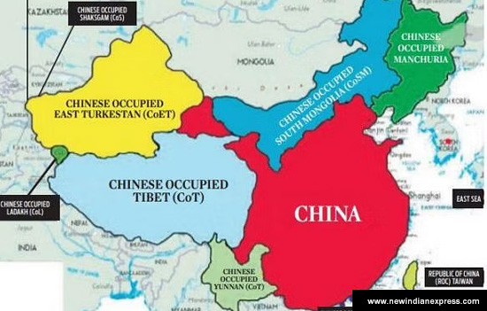 Map of China showing acquired regions.
I have relied on information from online
search. In case of any errors please write in with references. As a student, I
am happy to stand corrected.
Brief Background“Following Kublai Khan’s invasion in the 11th century AD, China was incorporated into the Mongol Empire and was ruled under the Mongol-led Yuan Dynasty. The Ming Dynasty overthrew the foreign rule of the Yuan Dynasty in the late 13th century AD. In 1644, the Manchurian clans overthrew the reigning Ming Dynasty and established their own Qing Dynasty.” Source
In 1911, there was a revolution 1911 against the foreign
Manchurian Qing rule. In 1912 it was the Republic of China who occupied
southern Mongolia in 1919 claiming it as Inner Mongolia and Manchuria in 1945. Source
On October 1, 1949, Chinese Communist leader Mao Zedong declared the creation of the People’s Republic of China (PRC). East Turkistan was renamed as Xinjiang in 1949
and Tibet conquered in 1951.
Mao Zedong said Tibet is China's palm and has five fingers namely Ladakh/Sikkim/Bhutan/Nepal and Arunachal Pradesh. Similarly, China laid claim to Galwan valley saying it is part of its ‘Xinjiang Uygur Autonomous Region’. How did Xinjiang become a part of China?
This article covers, in brief, acquisition
of Xinjiang, Tibet, Aksai Chin, Inner Mongolia and Manchuria. Read and decide.
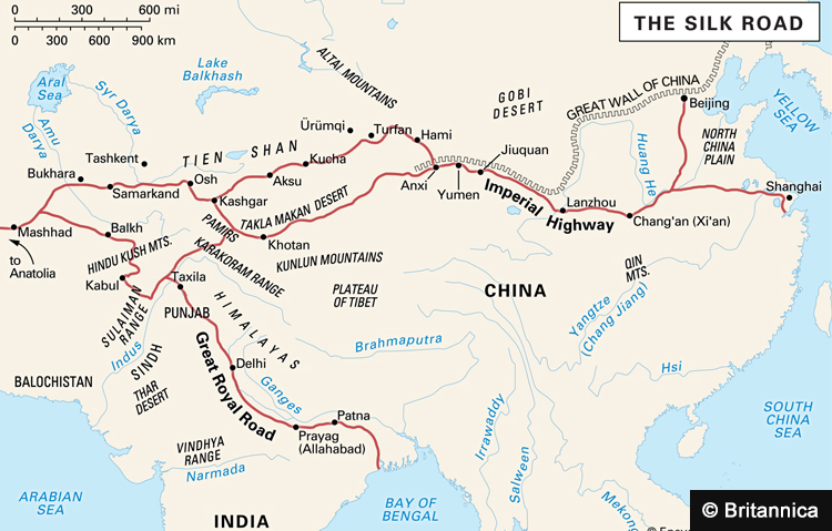 See Silk Route to China. Note area covered by the
Great Wall of China.
See Silk Route to China. Note area covered by the
Great Wall of China.
1. Xinjiang or East Turkestan (area
app 16,64,000 sq kms)
Most of Xinjiang (the new frontier) is dominated by the Tarim Basin. The first millennium C.E. was the golden age of the Tarim Basin,
as various Buddhism city-states thrived along the
Silk Road: Kashgar, Khotan, Turpan, Kucha, Niya, Loulan, among others.
Prof Shashibala wrote about Buddhist sites in Xinjiang, “Hsuan-tsang passed through Kashgar or Kashi (which he refers to as Ka-sha) in 644 on his return journey from India to China.” Two especially famous Buddhist sites include the
Kizil Caves
in northwest Xinjiang and the Bezeklik Thousand Buddha Caves in northeast Xinjiang Source
In Kizil Caves are also found mural of Shiva Parvati.
Read India has forgotten Khotan, Tarim Basin was Kashmir’s twin
Read Buddhist sites
in Xinjiang
The whole region came under Mongol rule
and was fully Islamicised by the 14th century. Later, the Qing
dynasty overthrew its rulers and conquered the area in the 18th
century (1759).
“The Qing dynasty was the ruling house of China from 1644 to 1911. Its ruling elite were originally Manchus from the steppes and forests of north- east Asia and they ruled with the assistance of Mongolian allies and Han Chinese officials. It was in 1884 that eastern Turkestan was included within the territory of the Chinese Empire.” Source Historytoday.com The British helped the Chinese conquer Xinjiang in order to keep Russia out of India. Peter Briton wrote in
the medium, “Xinjiang” as one unified entity didn’t even exist until 1884. Before then, modern-day Xinjiang was made up of two regions: the Tarim Basin and Dzungaria.”
Former diplomat Dilip Sinha wrote in The Times of India, “A word about the Qing (pronounced, ching) dynasty. It was the name taken by a Manchu dynasty that had conquered China a century earlier. The Manchus lived to the north of China, well north of the Great Wall that the Chinese had built to protect themselves from such invasions. The Manchus were not Chinese.”
However, in “the
mid-17th century, the Manchus
broke through the Great Wall and encroached on Beijing, eventually forcing the fall of the Ming Dynasty and beginning of the Qing Dynasty.” Source
When the Qing dynasty collapsed in 1911,
the rulers did not declare independence. In 1949, the People’s Republic of China (PRC) tried to consolidate control over
Xinjiang.
“According to the Chinese government, Xinjiang has been an "inseparable" part of China for more than 2,000 years. Many Uighurs dispute that view of history, however, characterizing Xinjiang as an independent region that, much like Tibet, has a distinctive cultural and political history.” Source
Sinha also wrote, “The claim of the Chinese Communist Party to Xinjiang is based on the imperial conquests of the Manchus even though the Chinese people regard the Manchu rulers as foreign occupiers. Yet, China regards the conquests of the Manchus as its historical inheritance.”
Read When did
Xinjiang become a part of China
Much is made today of the Silk Route. Author and historian William Dalrymple told the Indian Express, “In
fact, despite its modern popularity, the idea of a Silk Road-an overland trade
route supposedly stretching all the way across Asia from Xian in China to
Antioch in Turkey-was completely unknown in ancient or mediaeval times: not a
single ancient record, either Chinese or Western, refers to its existence.
This is not to say that the Silk Road did not exist at all. It certainly existed during the Mongol period (13th and 14th centuries CE) when the whole area between China and the Mediterranean was under one Mongol Empire.”
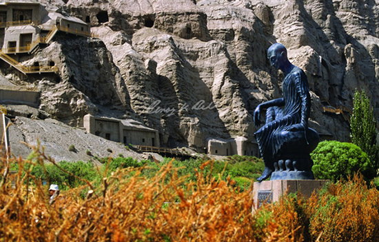
2. Tibet (area
app 12,20,000 sq kms)
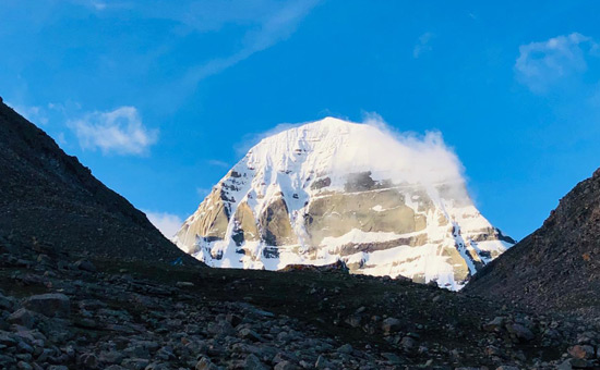 Mount Kailash is sacred to Hindus, Buddhists, Jains and Tibetans.
Tibet expert Claude Arpi wrote
about the Battle of Chamdo (Tibet) in the United
Service Institution of India, “It
is generally known that the PRC had annexed Tibet through the use of military
force in 1950-51 but not enough is known or written about - how it was
achieved?
In that context the Battle of Chamdo is an important landmark, for it was this battle that opened the door for the PLA to march into Tibet. Yet, the PLA on Mao’s directions chose to halt here and wait till the 17 Point Agreement between the PRC Government and the local Government of Tibet could be signed in Beijing on 23 May 1951 which opened the way for peaceful ‘liberation’ of Tibet by the PLA.
The occupation of Tibet was quite different from the annexation of Xinjiang which was primarily a military operation and was completed within 3-4 months, commencing on 12 Oct 1949. It may be remembered that the PRC came into being on 01 Oct 1949. As against this, for the ‘liberation’ of Tibet the PLA carried out preparations for nearly eight months (Jan-Aug 1950). Further, according to Mao’s instructions, the ‘liberation’ of Tibet was to be as much, if not more, a political affair than a purely military affair. Obviously there were sensitivities involved and these were well understood by the communist leadership of the time.”
Note
that with the collapse of the Qing (Manchu) dynasty in 1911, Mongolia and Tibet
declared independence in 1912 and 1913. They signed at Ulan Bator, The Tibeto-Mongol
Treaty of January 11, 1913. “Articles one and two of the agreement succinctly declare the formation of independent Tibet and Mongol States.” Source
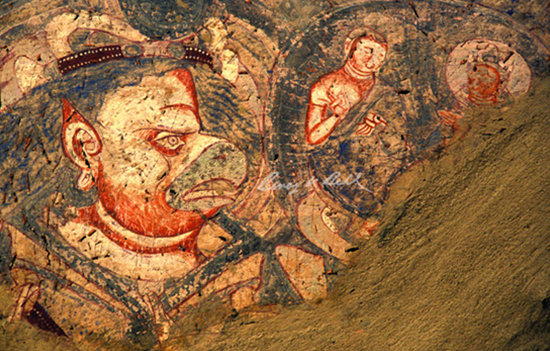 Garuda, Mural, Kizil Cave 178, Kucha, Xinjiang Uygur Autonomous Region Xinjiang. Pic by Benoy K Behl.
3. Aksai Chin (area app 37,000
sq kms)
Having got control of Tibet and
Xinjiang, China needed a road to connect the two hence wanted Aksai Chin. In
earlier times, traders went from Tibet to Xinjiang via Ladakh.
In 2013, Lt Gen N S Malik wrote in Indian Defence Review about the
strategic importance of Aksai Chin including Jammu and Kashmir.
“J&K forms the head of the Indian sub continent, and has been the traditional trade route of Central and South Asia to the East and Tibet, generally called the ‘Silk Route’. It is bounded by more countries than any other state of India; in the North East with Tibet, and further North with Xinjiang province of China, in the North West with the Wakhan corridor of Afghanistan, in the West with the Khyber Pakhtunkhwa province and further South with Punjab of Pakistan. This geographic layout is strategically important.
They wanted to grab those areas that
allowed it to establish roads between Sinkiang and Tibet. With the undetermined
border between Soviet Turkestan and Sinkiang
a source of friction and the tension with Russia, China needed an effective
line of communication with Sinkiang through Aksai Chin.
China is spending huge sums to build infrastructure through highways connecting Tibet to Xinjiang through the Chinese occupied Aksai Chin plateau, and Xinjiang to Pakistan via the Karakorum highway through the Kunzreb pass.”
I am not referring to the Shaksgam
Valley (app 5,000 sq kms) ceded by Pakistan to China in 1963, a region that
adjoins Xinjiang.
Strategic affairs analyst Maroof
Raza wrote in The Tribune, “If China has control over the Galwan valley, the Depsang plains (north of Leh) will greatly shorten the route taken by the Chinese - to link up with the Shaksgam valley, that China first grabbed and then made Pakistan ‘temporarily’ gift it to Beijing! This valley, though inhospitable, has the largest collection of glaciers (over 250 to be precise) that China regards as a source of water to further its agenda of world domination.”
 Statue of Kumarajiva, Kizil Caves, Kucha, Xinjiang Uygur Autonomous Region, China. Pic by Benoy K Behl.
4. Inner Mongolia (11,77,500 sq kms)
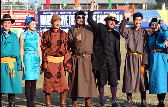 Mongolian guests at Polo Match, Sangai Festival Manipur 2014.
The Inner Mongolia Autonomous Region was founded by the Chinese communist regime in 1947 i.e. prior to the establishment of the People’s Republic of China in 1949.
According to this article, ‘Why is Inner Mongolia a part of China but not Mongolia’ “The establishment of the Mongolian Empire by Genghis Khan in the 13th century brought prestige and expanded trade to Inner Mongolia. Old raiding patterns returned with the Ming dynasty (1368–1644) in China, but peaceful relations with China were re-established when the Manchu rulers of the Qing dynasty (1644–1911/12) reorganized the tribes into banners and leagues and promoted trade through itinerant Han merchants.
After almost
300 years of rule, Manchus - Qing Dynasty eventually came to an end in 1911 due
to a massive Revolution in China. Mongols also managed to get rid of their
Manchu administrators.
Naturally,
Chinese 1911 revolutionary leaders insisted they would retain all the
territory, including Outer Mongolia, occupied under the Qing Dynasty. Hence,
they did not accept the independence of Outer Mongolia in 1911. Chinese
reluctantly accepted the independence of Mongolia merely after the Second World
War.
Inner Mongolians and Mongolians used to be one nation; however, unfortunately, due to historical events and their lack of political power at the time, they could not stay together as one nation. Obviously, due to its integration to China, Inner Mongolia has turned into a fusion of the two cultures.”
Read India and Mongolia – A shared heritage
5. Manchuria (15,54,000 sq kms)
Sinha, referred to above, also wrote, “The
Manchus attacked the Xinjiang region because the Mongols living there were
repeatedly raiding them. The Mongols themselves had ruled China for a century and had
always dreamt of re-conquering it. Their idol was Kublai Khan, the grandson of
Genghis Khan and the most famous Mongol ruler of China. Initially, the Manchus
merely attacked the Mongols to deter them from their raids. When this failed, Emperor Qianlong sent an army in 1755 to occupy the region. He incorporated it in the Manchu empire as a colony, not a province like the rest of China, and in 1768 named it Xinjiang.”
Kallie
Szczepanski wrote, “After the Mongols' Yuan Dynasty
in China fell in 1368, a new ethnic Han Chinese dynasty arose called the Ming.
The Ming were able to assert control over Manchuria and forced the Jurchens and
other local people to pay tribute to them. However, when unrest broke out in
the late Ming era, the emperors invited Jurchen/Manchu mercenaries to fight in
the civil war. Instead of defending the Ming, the Manchus conquered all of
China in 1644. Their new empire, ruled by the Qing Dynasty, would be the last
Imperial Chinese Dynasty and lasted until 1911.
After
the fall of the Qing Dynasty, Manchuria was conquered by the Japanese, who
renamed it Manchukuo. Japan launched its invasion of China proper from
Manchukuo; it would hold on to Manchuria until the end of World War II.
When the Chinese Civil War ended in a victory for the communists in 1949, the new People's Republic of China took control of Manchuria. It has remained a part of China ever since.”
6. Yunnan
This region is also shown as an acquired region in the map above. To know more read ‘Where China Meets India: Burma and the New Crossroads of Asia’ by Thant Myint-U.
Conclusion
Indians
must realize that China has increased its size, influence and world power
through acquisitions. Thus, India should not take declarations on
Arunachal/Ladakh lightly.
On Chinese approach to acquiring
territory former Ambassador P Stobdan explains it in this India Today article, “China started with its maximalist claim but settled for a minimalist demand to convey that it had compromised—given concessions to its counterparts—without actually losing an inch of territory. The last border settlement was with Tajikistan in 2011, when China claimed 28,000 sq. km but ‘settled’ for 1,158 sq. km, of land east of the Sarekole Mountains. The Tajiks had to cede land and were yet made to feel the victor.”
Even
before regions like Tibet became part of China, in 1921 Sun-yat Sen wrote about the needs of and resources of Tibet in The International Development of China.
The Chinese are clear and think long-term.
One way to deal with China is to cooperate and compete. This can happen only when India becomes an economic and military power.
Yet cooperation could be tough. K Subrahmanyam, a noted strategic thinker and author wrote, “A successful and democratic India, which rises fast and eliminates its poverty in a reasonable period, is the biggest challenge to the legitimacy of China... The competition between India and China is, therefore, an ideological one.” Source
Both countries have different worldviews.
China
wishes to promote its Tianxia system of “order under the heaven” as against India’s “Vasudaiva Kutumbakam” - all the world is one family. Source Sujan Chinoy wrote
in Hindustan Times that it is
surprising that China objected to the Sanskrit phrase Vasudaiva K esp. when it
has a Confucian saying Si Hai Zhi Nei Jie
Xiong Di (all the people within the four seas are brothers).
Read, reflect and decide. Utmost care
was taken in culling out data. Errors if any are not intentional and without
malafide intent.
Also read
1. The Tarim Basin was Kashmir’s twin
2. The
new map of border and areas around China
3. The Rama story and Sanskrit in ancient Xinjiang
4. Indology in China
5. Names of Buddhist sites in Xinjiang
6. Scholar pilgrims from India to China
7. India and China – The Great journey beyond and within
8. Tibet is at the heart of the India China dispute
9.
About the Great
Wall of China
10. Who built the
Great Wall of China and why