- What is the cause of flooding in Dehdradun and loss of life/homes in Garwhal during 2025 floods? What can government and people learn? We must respect nature. Garwhal is Dev Bhoomi, not Tourism/SUV Bhoomi. Why Kumaon does not flood like Garwhal?
Earlier Garwhal and Kumaon, two regions of the
current state of Uttarakhand (UTK) were part of Uttar Pradesh. The state of UTK
was formed towards the end of the year 2000. Ever since Dehradun was declared
the state capital it has seen a large increase in population. Due to improved connectivity Doon Valley is attracting lots of investment from Delhi-NCR, people who wish to escape pollution/heat there.
Till it became the state capital, Dehradun was a small town known for Doon School, Doon Valley and as a gateway to the popular hill-station Mussoorie. It had rivers within and on its outskirts. River Karligad (Sahastradhara), where the recent flooding incident happened, is now at the northern end of the city. Rivers Song, Asan, Tamsa and Suswa, which lie on the city’s outskirts have water to this day. Rivers Risparn and Bindal that are in the city have become drains.
Now, due to heavy rains in upper reaches the
water flow suddenly increased, causing flooding in the nearby houses and shops.
Such problems are not restricted to Dehradun alone. In the past five to seven years and more since UTK's formation, the state has seen an increase in tourist/pilgrim traffic, and number of hotels, restaurants, shops, and homestays along motorways has been increasing.
People are completely ignoring the sensitive
nature of the river banks, and this uncontrolled and unplanned process of
development continues unabated.
Now the goal is how to how to make the drive easier from Delhi-NCR to
Mussoorie through Dehradun for the comfort of tourists, never mind the carrying
capacity of Mussoorie.
Now the state government has proposed an elevated corridor in Dehradun, right on the riverbeds of Rispana and Bindal, to decongest traffic. Decades ago these rivers were perennial but due to encroachment and urbanization they have become drains. This means numerous concrete pillars would be placed inside the two rivers, trees cut, river life and families displaced. Even if families are rehabilitated, what is being forgotten is that Dehradun is part of the fragile Doon Valley. Once destroyed, its rivers, aquifers, and forests cannot be restored. Further, has anyone thought of the impact of the next major flood on these pillars in the rivers!
Due to its unique environmental and climatic variations, landslides, floods, and cloudbursts are common occurrences in UTK. Flood silt from the Kheer Ganga River in Dharali (where cloudburst took place in August), this alluvial fan (the flat and
moderately sloping area where Kheer Ganga meets the Bhagirathi River in Dharali
is shaped like a conical fan. In geographical terminology, this type of
landform is called an alluvial fan), extending up to the banks of the Bhagirathi River, has been flooded numerous times in the past and has even changed its course.
Earlier, ancient mountain communities, with a deep understanding of folk science, had traditionally built their homes based on safe topography, geological structure, sunlight, and wind direction. Following this understanding, they never attempted to encroach on river paths.
Now, we attempt to conquer all. The humility
of earlier times has gone.
Also, the process of increasing urbanization in small towns and cities along the roadside has disrupted the local ecological balance increasing trend of uneven development in the region. Further, insensitivity towards the Himalayas, changing nature of monsoons have further increased the severity of this disaster NOT to forget human settlements near where the river flows, around landslide prone areas and along highways that have old landslide sediments.
These factors combined have intensified the
impact of the floods and increased the risk to local communities.
These incidents are also destroying the rich
biodiversity of the region. We must remember that Hill States are major sources
of Ayurvedic herbs and flora/fauna.
View of two more residents of Dehradun
Mukul Prakash writes, “The message from this dhara of destruction and
death that Doon has faced is not for scientists and intellectuals. It is for
you and me fellow citizens. A call to bring back the harmony that has
created our unique city, it has a message - stop construction on flood plains,
stop the wanton deforestation, now. Most of all we need to put a stop to the
pervasive sense of cynicism and lack of concern for consequences that seemingly
dominates planning processes.
We need new cities, tourist centres, and ways
to accommodate the millions who wish to visit our beautiful state, but can this
be done by allowing destruction of whatever we have?
Let us allow Sahastradhara to live.”
Ajay
Chaturvedi gives three reasons -
1. “Heavy Monsoon Rainfall: Intense and
concentrated rainfall overwhelmed rivers, streams, and drainage systems.
2. Deforestation & Urbanization: Hillsides
and catchment areas have lost vegetation, reducing water absorption and
increasing surface runoff.
3. Riverbed Encroachment & Blocked Drains:
Construction near rivers and clogged drains hinder natural water flow, leading
to overflow and urban flooding.
We must learn –
1. To live in harmony with nature, respect it and not try to dominate it.
2. That the plains model of development will not work in the hills.
3. That UTK is in the sensitive category from a geological perspective.
4. To ascertain the carrying capacity of the hills and restrict visitors to that.
Garwhal is DEV Bhoomi (pilgrimage) not Tourism/SUV Bhoomi.
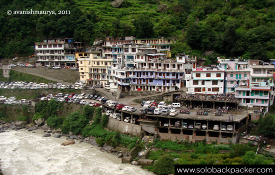 Multi-level car park at Govindghat, off highway to Badrinath, base for Hemkunt Sahib & Valley of Flowers.
Why does Kumaon not flood like
Garwhal does?
Total UTK area is 53,483 sq kms of which Kumaon is 21,000 so much smaller than Garwhal.
According to Uttrakhand based social activist, Anoop Nautiyal the reasons are many. “The Garwhal region is geologically more fragile compared to Kumaon, lying closer to the Himalayan fault lines. Garwhal also has more glaciers. With risks from glacial lake cloudburst floods (GLOFs) increasing in frequency and intensity, the inherent risks in Garhwal are higher. The Ganga and numerous rivers that dot the Himalayan landscape in Garhwal are glacial fed and larger than the ones in Kumaon.
Coming to the man-made differences.
Garwhal has the annual Char Dham Yatra that attracts lakhs of devotees/tourists. Many of them come by cars/SUV. Their fumes along with those from helicopter services that run across Char Dham pollute the atmosphere. To serve the same tourists and to an extent for defence needs, four-laning of the roads to Char Dham. It also matters how roads are made – when made from cutting mountains. If the malba-rubble from mountains is dumped into rivers it is bound to have an ecological impact. Overall excessive concretization of an ecologically sensitive region.”
Om Shanti
To read all
articles by author
Also read
1. Why
the Himalayas Need Sustainable Infrastructure-Building
2. Floods
in North India - Are We MANUFACTURING DISASTERS
3. Ropeways
to Kedarnath and Hemkund Sahib Are AVOIDABLE
4. River diverted by Dehradun Resort Owner