- Article
tells why we should now say Ladakh to Kanyakumari instead of Kashmir to
Kanyakumari.
Atalji said, “As warrior king leads other warriors, so does Sindhu lead other rivers.”
Adarniye Rashtrapati Shri Ram
Nath Kovind arrived in Leh town of UT of Ladakh on October 14 to first visit
Sindhu Ghat for Sindhu darshan and perform Puja before
flying to Northern Command headquarters in Udhampur and then returning to the
UT for celebrating Dusshera with troops. (President is Supreme Commander of
three defence Services).
This is the first visit of Ram Nath Kovind ji
to the Union Territory of Ladakh. With this visit a message flows from the UT
of Ladakh to Kanayakumari that Sindhu too symbolises extents of Bharat.
A
formal go for the observance of the Sindhu Darshan Festival was given in 2000
by the then Indian Prime Minister Atal Bihari Vajpayee. The festival was to he held
at Shey (about 15 kms from Leh city of then J&K State) where Vajpayee
ji quoted a hymn
from the Rig Veda
-
“Sindhu’s might surpasses all the streams that flow - His roar is lifted up to heaven above the earth, he puts forth endless vigour with a flash of light, even as cow with milk rush to their calves, so other rivers roar in to Sindhu. As warrior king leads other warriors, so does Sindhu lead other rivers.”
Vajpayee
ji also expressed that some people queried about existence of
Sindhu in India as described in our National Anthem but little did they
know that it flows from our soil in Ladakh symbolising 5,000 years ethos of
Indian civilization and its re-discovery will strengthen emotional integration
of country. So, it is Ladakh and not Kashmir valley i.e. the
northern most boundary of India.
With the reorganisation of the J&K State into two Union Territories the real size and people of the erstwhile J&K state have been more closely made known to the outside world.
Also
known is that J&K is not represented by Kashmir only. Actually Kashmir has
a very small area as you can see in table above. There is much more land and voice
beyond Kashmir Valley.
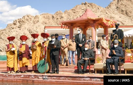 President Kovind on the banks of river Sindhu 2021.
Rather
with the enactment of THE JAMMU AND KASHMIR REORGANISATION ACT, 2019 NO. 34 OF
2019 the state of Jammu and Kashmir was divided into the Union Territories of
Jammu and Kashmir and Ladakh.
The Union territory of Ladakh comprised of Kargil and Leh districts. Area covered by Leh district was soon corrected. The territories of Leh District of UT of Ladakh were to constitute districts of the existing pre-1947 State of Jammu and Kashmir, namely, “Gilgit, Gilgit Wazarat, Chilas, Tribal territory and ‘Leh and Ladakh’ except present territory of Kargil.”
Accordingly maps were also issued first time very clearly showing the areas occupied by Pakistan and China as Indian territories clearing any doubts / myths about the extent of Bharat Varsh of the day i.e. limits from ‘Ladakh’ to Kanayakumari.
There
have been some myths about J&K that got cultivated over the years. It will
take some time for people to get used to the phrase Ladakh to Kanyakumari
instead of Kashmir to Kanyakumari but so be it.
For
obvious reasons some are unhappy with the state of Jammu and Kashmir becoming a
U.T. However, Prime Minister Narendra Modi has repeatedly said inside and outside
Parliament that at an appropriate time the Government will make the U.T. of
J&K into the state of J&K.
So remember it is now Ladakh to Kanyakumari since Ladakh is India’s northern most part and Kanyakumari is southernmost.
Author is a Senior Journalist and leading scribe J&K affairs.