- Read
about a very exciting and tough drive from Leh to Zanskar Valley. With the
completion of this road it is now an alternative route between Leh and Manali. See
pictures and video link too. Kudos to BRO.
Text by H V Kumar, Photos/Videos by
Sunil Titto and Bhaskar Mandakapa.
The
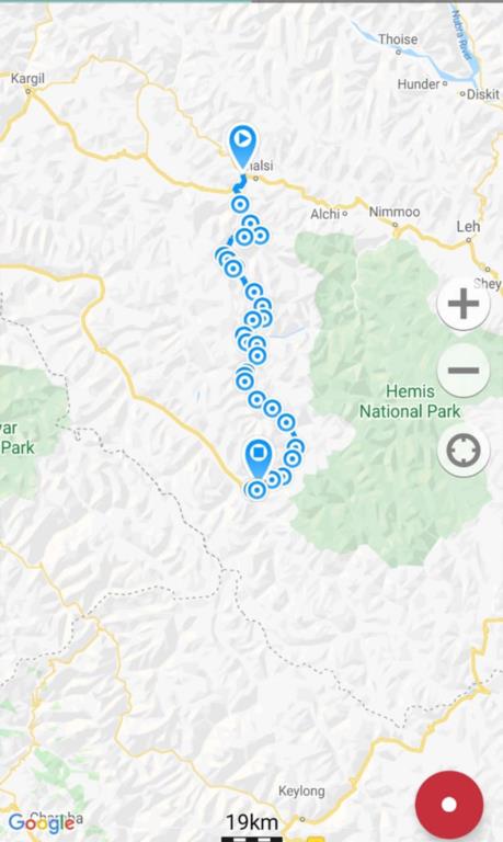
distance from Lamayuru to Padum is 190 kms. The route is Lamayuru- Wanla-Hanupatta-Sirsir
la-Photoksar-Singe la-Zangla-Padum.
190 kms does not sound too long a distance, but each km of this new road brings about radical transformation for remote villages that have remained hidden for centuries – and for whose residents, life will no more be the same again, as their access to modern facilities and the outside world expands; so will their economic status and social outlook. This new road opened during the summer of 2020. We did the drive in August 2021.
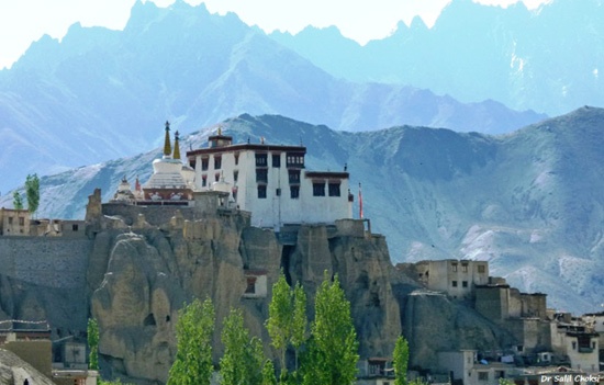 Lamayuru Monastery.
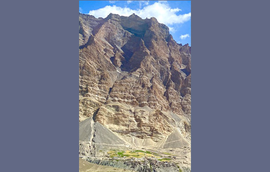
It starts off from near the famed Lamayuru Monastery on the Leh-Kargil highway. This is not an ordinary road – and definitely not for the faint-hearted; except the First 20 kms and the Last 50 kms, the remaining 120 kms is a dirt road. Even where the road is good, it clings on to the cliff side precariously high above the valleys and the rivers below. One false move could be fatal.
There are very few human settlements enroute, with large swathes of No-Man’s Land in between the small villages that appear to be totally self-sufficient for their daily needs, but lack standard facilities (except basic tea shops in Wanla & Photoksar) that a passing traveller would want.
Sirsir
la and Singe la are 4800-5000 metre high passes on this route.
August
is probably the best time to do this route, conditions are mostly dry. Between
October-May, the road will be snowed down and villages in this region totally
cut off from the rest of the world. Many villages on this route are connected
to the rest of the world by road for the first time, and mobile telephony is
fast bridging the gap of centuries.
The BRO has worked for almost a decade to “carve” this road out of the rocky cliffs and it does a commendable job of ensuring that it remains open and motorable amidst all odds. Needless to say, this is one of the “unmapped” regions of India.
Lamayuru-Wanla 3100 mtrs-Fangila 3250 mtrs, 15 kms
After
turning off the Leh-Kargil highway in the Khaltse-Lamayuru sector before
Lamayuru, the road winds along the river (tributary of River Indus). Wanla is
the first small village which has a couple of homestays and a gompa, followed
by the Terchit village. The villages cultivate their own rice and vegetables,
and appear to be largely self-sufficient.
Thereafter,
it is total wilderness with no human habitations for the next 20 kms. Greenery
totally disappears. Expect no traffic, barring the random Sumo/ Scorpio taxi
(and a HRTC bus from Lingshet to Leh).
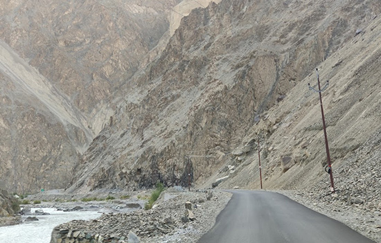
Fangila 3250 mtrs-Hanupatta 3700 mtrs-Sirsir La 4800 mtrs, 30 kms
After
Fangila, the tar road ends, the dirt road climbs up along with the river,
towering cliffs on both sides. The ascent is steep in some sections with sharp
hairpin bends, as the road struggles to cut its way through a few mountains to
get to the next range.
Hanupatta
is a small village which comes and goes before you know it but has some patches
of greenery. The next 20 kms is steep climb to reach the first high pass Sirsir
la at 4800 metres.
Sirsir LA 4800 mtrs-Photoksar 4200 mtrs-Sirsir La Pass 4900 mtrs, 40 kms
The
road descends steeply from Sirsir la to reach the Photoksar village which is a
brilliant essay in green amidst the sea of yellows and browns. Have little
expectations of Photoksar, there is a small tea shop which serves Maggi &
Rajma Rice, Coke and Tea. The tea shop guy tells us that winter temperatures
range up to minus 35-40 C, and the road from Lamayuru to Photoksar is ten years
old.
One
can see the Photoksar Monastery atop the hill. Buddhism is the dominant faith
of the people in this region, and the Gompas dominate the landscape at almost
every large village. Throughout, expect some river or the other to keep you
company on this route.
After
the deep valley that Photoksar is in, the road climbs up steeply again to
almost 5000 metres to touch the Singe la Pass. There are no human settlements
anywhere after Photoksar.
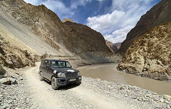
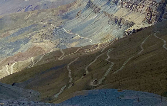
Singe La 4900 mtrs-River Zanskar 3300 mtrs, 40 kms
After
having gone up and down the roller coaster of mountains till Singe la, the best
is yet to come. Imposing mountain faces threaten to land slide any time. 25 kms
down from Singe la, the road branches off to go towards Lingshet, Niraq and a
clump of villages nestling in the green valley. You descend steeply down 800
metres in 7 kms! Raising clouds of dust behind you, woe be to the car following
you (if any)!
The
road now follows a tributary of the River Zanskar, often driving through the
river water and some rocky nullah crossings, but happily not too full now
(Expect the road to be totally inundated early part of the season). And then
you are besides the mighty Zanskar River itself.
River Zanskar 3300 mtrs-Zangla 3450 mtrs, 35 kms
This is truly a cliffhanger drive-the road cut out of the cliffs, hugging the River Zanskar which is in full spate. One misstep and you can be in a “bullet train” to Nimmu. You are now on the “Chadar Trek” route.
Road
is dirt, gravelly, but easily motorable if you have guts of steel! The road gradually
climbs up far above the river and finally you are looking at the vast expanse
of the Zanskar Valley, with its vast grasslands and shockingly green paddy
fields. Villages, Green Fields and Gompas.
You
have arrived in Zanskar Valley. The road is now wide, tarred, holds no shocks
or challenges, and you can speed up to reach the first large village Zangla
which is 30 kms before Padum. Zangla has a Police Check Post where presently
(August 2021) all visitors are checked for RTPCR/ undergo RAT tests before
being allowed further.
Zangla 3450 mtrs – Padum 3550 mtrs, 30 kms
From
Zangla to Padum, it is a fast-paced drive on wide tarred roads with wide valley
landscape views, all along the River Zanskar. The famous Strongdey Gompa flashes up to your left, and before you know it,
you sight the first IOC petrol pump in the village of Kumik.
To
see VIDEO of drive
1.04 minutes
Padum
is the main town in the Zanskar Valley, a crucial junction with roads leading
to Manali and Kargil via high passes, permafrost glaciers and craggy
mountainscapes.
However,
lower your expectations on what will get in Padum- a few basic hotels, some
shops, a single petrol pump and even a couple of car garages!
With the
completion of the Lamayuru-Padum & Padum-Darcha roads, it is now possible
to drive from Leh to Manali on an alternative route. The BRO is also building a
Tunnel under Shinko La on the Padum-Darcha Road to weather-proof the road during
winter when the Shinko la Pass becomes snow-bound.
Author H V Kumar runs a very popular Facebook page on road travel. “There is nobody as expert as HV Kumar (HVK) on knowledge about Indian Highways and Automotive Transport. The magnitude and the detailing of precious and up to date information he has is mind boggling and absolutely unmatched.” To access FB page click HERE
Also see
1. Drive
Leh to Kargil
2. Journey
to Phuktal Monastery, Zanskar Valley
3. Drive
Srinagar to Leh
4. Drive
Manali to Srinagar
5. Cycling
Manali to Leh
6. River
Rafting Zanskar
7. Drive
through Sinthan Pass to Kishtwar
8. Drive
Chandigarh to Leh
9. Drive
to Changla Pass